- PROJECT MOTHER
- someone
- Information for Middle and High School Researchers
Observe the Earth's changes through unmanned patrols of the great ocean.
2021.03.12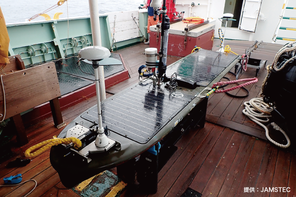

Japan Agency for Marine-Earth Science and Technology
Marine Seismology and Volcanology Division
Research and Development Center for Earthquake and Tsunami Prediction
Earthquake Prediction Research Group
group leader Takafumi Iinuma three
Ten years have passed since the Tohoku-Pacific Ocean Earthquake of March 2011. The Japanese archipelago, which straddles four plates, cannot escape the threat of a massive trench-type earthquake.
Tracing the Mechanism of Mega-Earthquakes
To understand earthquakes, it is important to understand the slow but steady movement of the earth's crust. This allows us to predict the magnitude and interval of earthquakes and to prepare for them. However, the plate boundaries that generate earthquakes are located at the bottom of the ocean, more than several tens of kilometers away from land. It is not possible to capture the details of the plate boundary from land.
To investigate the effects of this crustal movement, a number of observation points have been established around the Japanese archipelago. To conduct the survey, a research vessel equipped with acoustic equipment moves to the observation stations on the seafloor and emits sound waves toward the seafloor. The distance between the research vessel and the instruments on the seafloor is measured based on the time it takes for the sound waves to travel.
However, in some cases, researchers board a research vessel and spend nearly a month on the voyage," says Iinuma of JAMSTEC. During that time, the data analysis cannot proceed, and the cost of moving the ship is high," says Iinuma. This is why development of unmanned observation systems is being vigorously pursued in many parts of the world.

Wave glider recovered after the sea observation voyage. GNSS antennas are mounted on the front and rear.

Wave glider wake diagram, deployed at station G04 and retrieved at station G14.
Run with the power of the waves! Glider
Wave Glider, one of the unmanned observation systems, is an observation aircraft that automatically and autonomously navigates through the ocean by converting waves into propulsion. Iinuma et al. started test observations using this unmanned ocean observation system in 2019. The wave glider used in this project is a third-generation model, which has been improved since the first-generation model introduced around 2007. It is self-sufficient in the power needed for navigation and operation of observation equipment through its onboard solar panels. This means that the ship does not need to return to the mother ship or port for refueling and can operate for a long period of time.
Iinuma et al. had the wave glider fly around 14 observation points over a period of about one month to see if it could acquire observation data in the same way as using a ship. As a result, they confirmed that they could acquire sufficient GNSS observation data, attitude, and acoustic ranging data to detect crustal deformation on the ocean floor with the same level of accuracy as when using a ship. The cost of data acquisition was reduced to one-tenth. This method may make it possible to observe a wider area more frequently and monitor crustal deformation in greater detail.
The Slowly Changing Earth
Analysis of the observation data so far shows that over a long period of time after the Tohoku-Pacific Ocean Earthquake, the seafloor off the coast of Fukushima Prefecture to Ibaraki Prefecture moved slowly to the east and the seafloor off the coast of Miyagi Prefecture (just above the area where the earthquake caused a large slip) moved slowly to the west. This kind of crustal movement that occurs after an earthquake is called yo-ko-variation.
Iinuma says, "To capture the slow changes in the earth's dynamics, we need to continue observations for at least three years. Iinuma says. Research on the Earth requires thinking over a long-term span of 5 to 10 years. I feel that we are finally beginning to understand what was happening at the time of the Tohoku-Pacific Ocean Earthquake," he says. One of the most exciting aspects of his research is that he is able to unravel past events from current data. Our understanding of the Earth is slowly but surely advancing.
(Text: Kaori Nakajima)